Uncommon Places – Stephen Shore’s photographs of American towns in the 1970s
One of the seminal books on modern America’ – British Journal of Photography
Stephen Shore’s book ‘Uncommon Places’ shows us photographs of American towns in the mid 1970s. But it is not a documentary book about these places, it is a photography book, about light, colour and picturing the landscape. Shore’s photographic concerns were about how the flatness of a photograph and the framing transforms meaning. It is geographically and thematically disordered, and the photographs of places are randomly alongside pictures of chairs, food and his girlfriend.

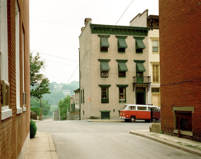
Main Street, Gull Lake, Saskatchewan, August 18, 1974 (p75)
Photographically, the book is significant because at a time when photography was dominated by black and white 35mm reportage, Shore used a 10 x 8 inch plate camera to make fine colour images of blandly ordinary subjects. It stands as a direct counter to Ansel Adams’s majestic American landscapes. Shore was part of the New Topographics exhibition that challenged landscape traditions by showing landscape altered by development. Lewis Baltz said:
‘The present generation of Americans, for the most part, never experienced the landscape without experiencing its counterforce, industrialism….. In this awareness topographic photographers surveyed the ‘new’ American landscape, attempting to see it whole and see it clear; motorways, shopping centres, housing tracts and all of the other elements that inform our perception of a landscape neither wholly natural nor wholly an agglomeration of industrial artefacts, the ‘middle landscape’ of late industrial pastoralism.’ Lewis Baltz, in American Images, 1985.
But of course it is documentary – these photographs represent a physical and cultural reality.
Shore says, ‘Between 1973 and 1979 I made a series of trips across North America, photographing with a view camera. These were essentially journeys of exploration: exploring the changing culture of America and exploring how a photograph renders the segment of time and space in its scope. I chose a view camera because it describes the world with unparalleled precision…. because it’s the photographic means of communicating what the world looks like in a state of heightened awareness.’ Stephen Shore, in the book Uncommon Places: the Complete Works republished in 2004.
In cities and towns across the USA and Canada, Shore selected views of ordinary streets, buildings and car parks – usually just one photograph in each town. These images are not of grand, set-piece buildings and parks but of commonplace urban locations, nondescript functional buildings and businesses that have evolved around the car. Contained within each photograph is visual information about the land use and economy of these places. His book provides a document of America at a specific point in time equivalent to Eugene Atget’s document of Paris in the early 1900s and Walker Evans’s 1930s photographs of new American towns and buildings.
The book’s introductory essay and the interview with Shore say nothing about the urban conditions Shore is looking at. So in this article, I am asking, what do the pictures tell us about these urban places at that time? If an ‘art’ photographer uses the urban environment as subject matter, it is legitimate to read and interpret the urban development we are shown, even if this was not the photographer’s intention. The landscape photographs are a biting critique of the urban condition of the USA and Canada, but commentary articulating this has never accompanied these photographs.
In terms of content, the subject matter, Shore said:
‘a photograph can describe but it explains very little.’
‘You can go from edge to edge in a picture and put into words a description of everything you can see and that description might take five minutes to read; you lose the simultaneity of experience and to see that [photograph]…. all at one time – you can’t get that experience of simultaneity, the simultaneity of relationships in words, because simply its a linear medium and it takes time to work through them. So photographs describe in a way words cannot possibly describe.’ ‘Architectural Association talk, October 2010
That is understood, but I am going to risk the sacrilege of explaining in words what we see. I believe words help to deepen the understanding of a photograph without compromising this experience of the image. It enhances our appreciation of the image by appreciating the subject matter. There remains a problematic distance between the photograph’s ‘description’ of these banal places, and knowledge of the urban condition it shows.
Reading Shore’s urban landscapes
Shore’s landscape photographs reveals the prosaic physicality of American towns, their buildings, roads, businesses and especially car parks (car lots). ‘Shore accepts the threadbare banality of the American scene, the jerry-rigged, down-at-the-heels seediness of our rural landscapes and the spatial looseness of our towns, recapturing the overfamiliar, making it poignant, coherent, and almost lovable’
Robert Venturi, Architect

Main Street and Second Avenue, Valley City, North Dakota, July 12, 1973 (p27)
The title of the book is ironic, because the photographs are of common places, the commonplace. But he chooses uncommon viewpoints, side streets, across car parks. Shore understands the way a photograph reveals surface appearances, the texture and materiality of things. In Stephen Shore’s street scenes a lingering gaze transforms the ordinary into an intense fixed presence.
What do we see? Everyday, familiar scenes revealing every surface, sign board, lamp post, pothole, doorstep, hubcap. Incidental detail that reveals activity – a boat on a camper van roof, tool bags on a car roof rack. Desolate, open blandness across car parks and of shopping malls. He photographed the urban ‘nowhere’. It is the absences that are most telling: an absence of trees and parks, architectural distinctiveness, local culture or materials, any unconventional activity.
It might seem a damning portrayal of American towns in the 1970s. But André Corboz warns against using a European critique to disparage the undifferentiated structure and ugly appearance of the American city.
The urban morphology of the American landscape
Nearly all Shore’s landscape photographs reveal part a rigid urban grid pattern, and tell us what a powerful effect an orthogonal block street layout has on towns across north America. ‘…the American city is formulated almost exclusively on a system of orthogonal coordinates. This is its most flagrant feature, the one to which all its detractors reduce it.’ André Corboz. The National Land Ordinance, under Thomas Jefferson in 1785, ensured that the urban blueprint for most of the USA would be the grid. In locations across the country,orthogonal street blocks extending into the country were divided into building lots ready for speculative development. ‘The grid’s concomitant ubiquity left American cities in a permanent state of indeterminacy with respect to their geographical surroundings and their internal order’ Kurt W. Forster, Looking for a City in America.
This is a book of the urban grid, whether city centre or undeveloped edge of town. It is the urban grid Shore shows occupied by unrelated buildings and gaps – ‘the blank configuration simply awaits filling in according to local zoning regulations, which often provide little constraint.’ André Corboz. While it was uncommon to photograph these places with such artistry, this urban form does not make ‘uncommon places’ at all, rather it makes ubiquitous places. There are only two instances in the book where Shore has photographed places on a non-orthogonal plan – Market Street in San Francisco and El Paso Street in El Paso.
Urban location
The key to interpreting an urban photograph is understanding its location within the city. Across the towns in Shore’s pictures, we see central business districts, downtown areas, ‘Main street’, the commercial strip along arterial roads, residential suburbs, out of town retail, the rural fringe, the urban interface with river and forest, and open countryside. Shore doesn’t order the pictures in any spatial way. A single photograph from each town hardly represents its complexity. Yet because Shore goes from city centre to city periphery to choose single shots in each place, the whole book represents the geography and economy of one American city in the 1970s. The following sequence represents a typical cross section from edge to centre of ‘Any City’ in North America:
 The open country and Expressway
 Rural economy – landscape heritage visitor attraction
 New housing on the edge of town
 The start of the commercial ‘strip’ – roadside business and service infrastructure
![]() Car-oriented services on the arterial roads
Car-oriented services on the arterial roads
 Out of town shopping
 Suburban ‘main street’
 Entering downtown
 Old inner city businesses
 Central business district
Downtown
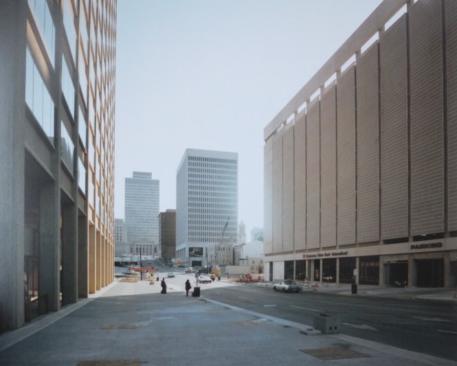
This photograph is the most topographic, most map-like in the book. It is not typical of Shore’s distinctive photos, but key to all of them. It is a city centre. Viewed from above, it shows the urban grid extending across Amarillo’s downtown, with each uniform-sized block containing buildings of different ages and different uses. Two blocks are half occupied by car parking. We see a civic building in parkland occupying a block. In the foreground, a ‘main street’ containing a cinema and shops extending to half the block depth.

Amarillo, Texas, October 2, 1974 (p89)
What we see in these photographs is what happened after original development as the result of post-war acquisition of land by the city authorities and clearance of housing for urban renewal. Spiro Kostof explains, ‘With urban renewal, sites are wiped clean and the scale radically changed, as small units are replaced by large monolithic structures and open spaces…. the blocks are gradually thinned out to provide parking lots, punctuated by fragments of the old structures and widely spaced skyscrapers…[In Houston] up to 70% of the central business district is now taken up by roadways and parking. the lots also form a holding pattern for properties awaiting development’

West Fourth Street, Little Rock, Arkansas, October 5, 1974 (p84 )
Hence, this photograph shows cleared sites for car parking, the landscape within such a sucked-out city centre, with fragments of old buildings standing isolated and an incongruous tall block which requires the car parking.

West Market Street and North Eugene Street, Greensboro, North Carolina, January 23 1976 (p121 )
And in this photograph, a theatre, a churches and the backs of boxy commercial properties create a disconnected skyline across the highway and car parks, with no built frontage on the main road.
The Central Business District
A central business district (CBD) is the commercial and business core of a city. In larger cities, it is often synonymous with the city’s financial district.

Sixth Street and Throckmorton Street, Fort Worth, Texas, June 13, 1976 (p125)
In the central area of Fort Worth, Shore looks from an open car lot past a bus shelter, towards the domed 19th Century civic building, a remnant commercial building (possible boarded up) and an incongruous, brand new high-rise office building with a flared base, each occupying the same size block within the street grid.
The character of these areas is fragmented and boundless. In the light of European cities we find this appearance ugly. But they represent a capitalist system of land transaction and development accepted by Americans. ‘The decisive fact is… the tendency not to cherish the core of the city… is psychological: Americans have a collective horror of the city centre, in opposition to which they have posited the garden city ideal… The American public categorically avoids going “into town” except out of necessity’ André Corboz, Looking for a City in America. The downtown is a centre of commerce, rather like a industrial estate, that you go to for making money.
Deaderick Street, Nashville, Tennessee, May 2, 1974 (p40)
This picture shows new buildings in Nashville’s CBD – offices with car parking under on the right, office buildings in the distance in the dense centre. This photograph also reveals distant glimpses of the neo-classical buildings Nashville is famous for, subsumed by speculative offices.
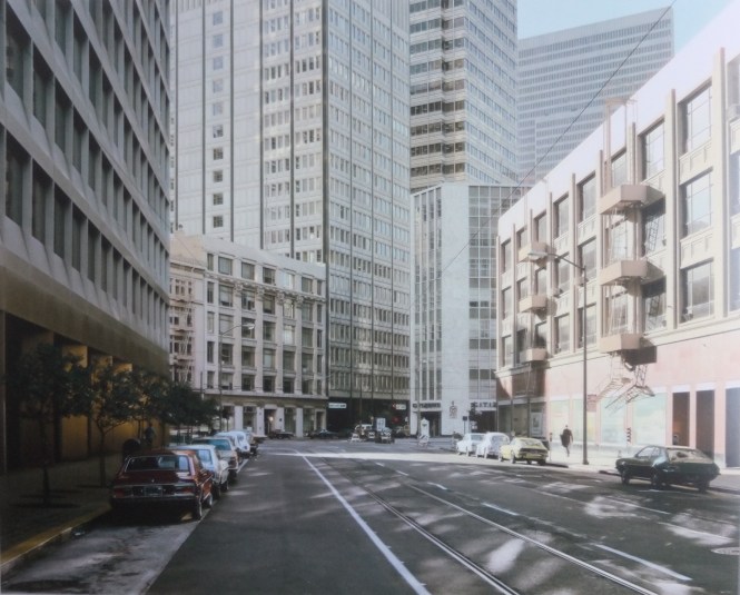
Market Street, San Francisco, California, September 4, 1974 (p86)
This is in the CBD of San Francisco. An untypical picture where the grid does not prevail. Market Street is where two grids intersect with streets not meeting at 90 degrees.
Shore includes two photographs of the CBD of Little Rock. They show the same two office buildings, a multi storey car park and single storey shops. One photo looks along a street, showing an ordered urban form, the other looks across a car park towards the street, impossible to locate the street, and showing urban disorder. These two images generate a different sense of the three dimensional space. What we can see in one (the spire at the end of the street, the old red brick building) is out of the frame in the other. It demonstrates the partial view any urban landscape gives.

West Fourth St, Little Rock, Arkansas, October 5 1974 (p90)

Center St and West Third St, Little Rock, Arkansas, October 5, 1974
The old city
Shore’s pictures of down town of old colonial towns show pre-elevator architecture, built of brick and stone, with decoration revealing their time. and showing true permanence. These photographs also reflect preservation ordinances, keeping the historic city fabric. The National Register of Historic Places was created in 1966, following a report by the US Conference of Mayors which which said that Americans suffered from a sense of “rootlessness.” They recommended historic preservation to help provide Americans with a sense of orientation.

Twenty-First Street and Spruce Street, Philadelphia, Pennsylvania, June 21, 1974
This location is the central, historic core of Philadelphia, where grand scale, solid masonry nineteenth century buildings create street edges, containing residential and civic functions. ‘Philadephia was the first large American city to be configured as a gridiron’ Spiro Kostof, The City Shaped, p145. The photograph reveals the urban presence of the buildings (one of only two landscapes in the book not showing the sky), echoed in the photos of the historic core of Spokane and El Paso below.

Lincoln Street and Riverside Street, Spokane, Washington, August 25, 1974

El Paso Street El Paso,
In this photo of El Paso’s downtown, signposts indicate an the historic walking route, and the plaque next to a dead tree shows there is historic interest. Whether Shore was interested or not, he took a photo of El Paso’s newspaper tree, used from the 1850s to post news and reinstated in 1941 by four businessmen.
Main street
Shore shows Main Street in the centre of small towns, the street in every town containing shops, banks, services, cinema, at the core of the town where building originally started. The architecture is wafer thin, with facades placed on the front of functional, flat-roofed buildings. 1950s flair distinguishes the First Federal Bank in Kalispell and the Roxy Cinema in Regina, below.
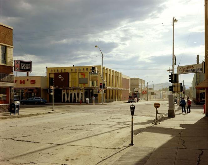
Second Street East and South Main Street, Kalispell, Montana, August 22, 1974 (p93)

Broad Street, Regina, Saskatchewan, August 17, 1974 (p73)
In the small towns and suburbs Shore photographed, the most striking architecture is the neo-colonial grandeur of civic buildings – town halls, libraries and churches built at the founding of the town. Apart from that, the street landscapes lack even the most subtle architectural interest, showing functional, poorly constructed buildings. Due to the clearing of blocks for parking, the boxy blank backs and sides of commercial buildings become prominent. In Main Streets, the buildings have applied decoration and huge fascia signs.
The Strip
More than anything else, Shore’s photos show the effect of the car on 1970s American towns. His photos always include a road, often at intersections, many are of car parks, the businesses are related to the car – gas stations, motels, and road-side shops, malls and restaurants recur in the photos.
![]()
Beverly Boulevard and La Brea Avenue, Los Angeles, California, June 21, 1975 (p115)
The American ‘strip’ occurs on arterial roads leading to and from a town, ‘that extension of the old main street, geared to a car-buying and servicing culture’ says Spiro Kostof, lined by car-oriented businesses – in this sense these photos are typical of American towns.

Fifth Street and Broadway, Eureka, California, September 2, 1974 (p92)
This photo (used on the cover of the book) provides the agenda for reading these photographs – the location, the relationship with the road, the type of business activity, the nature of the buildings, whether viewing a public or private space. This richly informative photograph is a private car park, on a side turning off the main road. It is the rear of Sambo’s restaurant, which faces an arterial road – a straight ‘commercial strip’ lined with used car sales, a tyre trader, motel and cement depot. All the buildings are single storey. The main road also carries overhead power and phone lines. These are all evident in this photograph – the sole image of Eureka, California. At the left edge of the photo we see the corner a motel pool.

Marland Street, Hobbs, New Mexico, February 19, 1975 (p109)
Here is another photograph looking at a side road off the strip, looking across a private, enclosed motel pool, with perforated wall.
This photo demonstrates a common feature of Shore’s pictures: showing the private side or rear face of property, rather than the public front. It is Shore’s views from private land that makes these landscapes less familiar, more revealing. In this picture Shore looks across private land from another private property. And although the buildings we see are single storey, Shore is elevated, on a roof top.
Urban interface with natural topography
‘If the urban scheme deviates occasionally from this rule [the orthogonal grid], it is because topography imposes the necessity’ André Corboz, Looking for a City in America. The relentless grid has to stop for rivers and forests.
There are a few photographs where the natural landscape gives much more form and meaning to the urban scene.
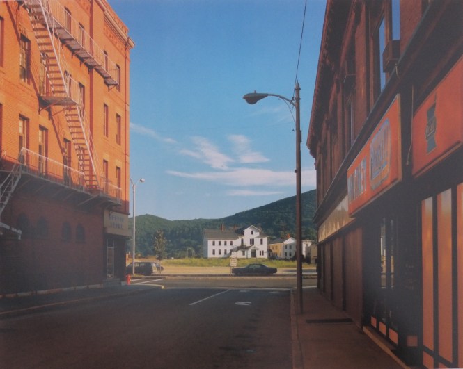
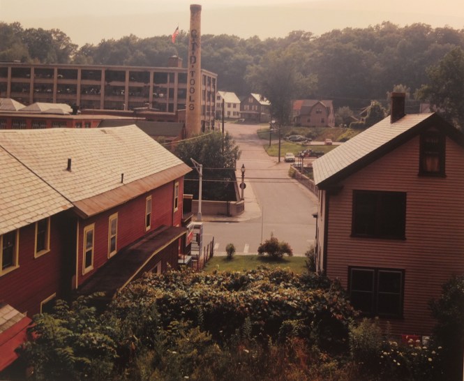
Holden Street, North Adams, Massachusetts, July 13, 1974 (p61 )
‘At the same time [as thinking about the photograph], I am thinking about how this New England industrial town ends. This street marks the end of the town, and the countryside begins, and I am interested in this transition.’ 2010 Architectural Association talk.
This is the only time I have heard or read Shore saying anything about the location, land use and urban form of the place in one of his photographs.
In the photo below of Easton, there is a similar condition, where the grid is interrupted and the street dips down into a valley.
Church Street and Second Avenue, Easton, Pennsylvania, June 20, 1974 (p45)
In the photograph of Greenfield, we see a valley bottom, a road bridging the river, remnants of an old tool making industry surrounded by woodland and houses.
Deerfield Street, Greenfield, Massachusetts, July 15, 1974 (p62)
Housing
Shore exhibited alongside Bernd and Hilla Becher, with their ‘typologies’ compiling examples of types of industrial structure, such as blast furnaces and water towers. Shore’s book contains typologies without being explicit. For example, cinemas, supermarkets, small houses, swimming pools. Across the book there are a few photographs of mass housing, hardly a typology in any documentary sense, but if put together provides an insight into different living environments.

Sunset Avenue, Palm Beach, Florida, October 28, 1973 (p36)

Wolf Street, Philadelphia, Pennsylvania, October 28, 1975 (p118)

South University Drive, Fort Worth, Texas, June 4, 1976 (p132)

Fromm Crescent, Regina, Saskatchewan, August 17, 1974 (p72)

Bozeman, Montana, 1981

Wilde Street and Colonisation Avenue, Ontario, August 15, 1974
The periphery
Shore goes outside the town and shows us the messy urban fringe, farms, land being prepared for development.

Presidio, Texas, February 21, 1975
‘The grid system does more than fill up voids between urban fragments so as to create a coherent whole; here it becomes the armature of a future agglomeration… one encounters straight avenues running perpendicular to the freeway.’ André Corboz, Looking for a City in America

California 177, Desert Center, California, December 8, 1976 (p134)
Conclusion: the 1970s urban condition revealed by Shore’s book
The cultural accompaniment to this book is David Byrne’s 1986 film True Stories, itself examining the American social landscape, through Main Street, a shopping mall, an edge-of-town housing development site, a suburban home and a factory in Texas.
Shore’s Uncommon Places may actually be a performance artwork – it is a road trip. Shore drove across the USA and Canada, the book is a diary and a record of the dull hotel rooms, breakfasts, his own stuff and bystanders from the trip; an road-trip antidote to Fear and Loathing in Las Vegas. ‘I chose a view camera because it describes the world with unparalleled precision…. because it’s the photographic means of communicating what the world looks like in a state of heightened awareness.’ A different heightened awareness to Hunter Thomson’s. The photos remind us that all photography is both a document of the real and a dreamlike surreality.
This book is a celebration of the plate camera as well as Shore’s seeing. Shore was had a mastery of light, colour and composition. His work was primarily about the visual nature of the photograph – , surface appearances. ‘A Shore picture is very quiet, very poised, very much at rest, very much with to do with the moments between events, and yet very potential. Not boring, not empty – but suspended.’ John Szarkowski, Museum of Modern Art 1979.
This article is not to take anything away from Shore’s art. It is simply that you cannot take art photographs of urban places without them being documentary accounts of that place. I wanted to examine the urban condition Shore shows us, to write the critique I had looked for but not found. We can go beyond Shore’s pictorial formalism to the structures and spatial relationships of the town and country. It is 1970s north America, it will have changed a lot, towns will have grown or stagnated, but the relentless grid will still be there.
