Image and influence: the High Line NYC

A famous photograph of the derelict railway on the High Line in New York City and two texts. The first quotation is from a book about photography; the second from a book about the campaign to transform the High Line into an urban parkland.

DSCF8521

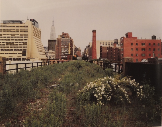
Joel Sternfield – Looking East on Thirtieth Street on a Monday Morning in May 2000. Chromogenic (Type C) colour print

‘Like many contemporary photographers, Joel Sternfield uses essentially the same equipment as the 19th-century pioneers – a large view camera, complete with black focusing cloth and tripod…. He has his negatives scanned and printed digitally.

‘This image comes from one of his best recent projects, for which he followed the High Line, a derelict elevated railroad track that runs for over a mile in Manhattan. The line is overgrown – improbably returned to nature within one of the most densely developed cities in the world. Sternfield photographed for over a year, in all seasons, doing nothing fancy, but giving us an unexpected and decidedly intriguing view of New York City.’

Gerry Badger, The Genius of Photography, 2007. Quadrille Publishing Ltd


The High Line is a celebrated urban regeneration project, which has had a major economic and environmental impact in New York and stimulated projects in other countries. Joshua David and Robert Hammond, West Side residents who had no prior experience in planning and development, led a campaign to protect the derelict railway structure and convert it to a linear park, leading to spectacular fundraising, political support and a major public space project, transforming the surrounding neighbourhoods. Joel Sternfield’s photograph was made for this campaign.

‘We wanted to photograph it. We had been up there and seen this incredible wildscape – seen the city in a whole new way – but people couldn’t see it from the street, and our own snapshots didn’t capture it.

‘I mentioned our need for photos to Ray Gastil, at the Van Alen Institute…. Ray said, “Why don’t you call Joel Sternfield for your photos?” He said Joel had taken pictures of aqueducts outside of Rome and some other industrial-landscape photographs.

‘I found his number in the phone book and called him – was he interested? As soon as Joel saw it, he took me aside and said, “I want to do this. Don’t let anyone else up here for a year.”

‘We got permission for Joel to go up there by himself, anytime he wanted to, to photograph the High Line for a year. We had no idea at the time that these photos would come to define the project and would propel it forward the way they did.

‘Later, I found out that Joel was a famous photographer.’


‘…. we gave the photos to The New Yorker. People remember Adam Gopnik’s article as being about the High Line, but it was really about Joel and his process. It mentions Josh and and me and our efforts – it calls us a group of “West Side do-gooders.”

‘I think of Joel as a third co-founder. The photos he took became important tools for us. Instead of showing people architectural renderings, we would show Joel’s photos.

People could read different things into them. In one of his most famous photos of the High Line, looking East along Thirtieth Street on the rail yards section, you can see the Empire State Building, an old metal railroad box, the tracks, the various plants, and lots of different buildings, old and new. Some people would look at the photo and see a preservation project. Some would see horticulture. Rail buffs would get excited about the tracks. Some people imagined architecture.’

Joshua David and Robert Hammond, High Line, The Inside Story of New York City’s Park in the Sky. 2011 Farrar, Straus and Giroux


Garry Winogrand and Ian Nairn: Chelsea 1960s

The influential American photographer Garry Winogrand came to London a couple of times in the 1960s – there are three photos taken in London in his retrospective monograph Winogrand: Figments of the Real World. 

‘A fast-moving street photographer who delighted in the complexities, banalities and bizarreness of urban life, he used intelligence, wit and his camera in roughly equal measures to make some of the most influential and frequently imitated pictures of the 1960s.’ American Images, 1985

DSCF8509

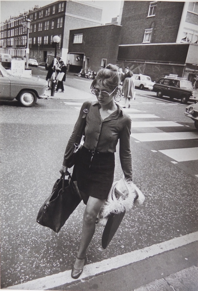
Garry Winogrand, London c.1967 

Winogrand took this picture of a woman in Kings Road, looking south along Walpole Street – though for him it was simply ‘London’. It is an incidental piece of London street scene framing the woman in a hurry. The road and buildings were of no consequence in themselves to him.

The first part of Walpole Street is a brick wall and a blank facade at the side of a shop facing Kings Road. It’s a supermarket – an articulated trailer with a Safeway logo is inside a loading bay. Kings Road is a local high street serving a dense neighbourhood: above the supermarket is a modernist apartment block. Beyond the loading bay and store, the side street becomes smartly residential, with a four storey terrace of houses and flats. It is a respectable solid building, with Victorian proportions, but the nearer part is a recent post-war re-building, designed to fit closely with the older original, but without the equivalent elegant refinement, without chimneys. On Kings Road, the road surface is most prominent – the white stones set within the freshly laid hot rolled asphalt, and a Zebra crossing: Kings Road is a London through-route.

The young woman is at work in the city. Neatly stylish, collar rumpled, she is dressed for the office or studio, carrying a portfolio as well as shoulder/hand bag and a capacious holdall. She is carrying an Afghan coat and wears large round glasses; conventional fashion, rather than Kings Road showiness.

Around the same time Winogrand took this picture, Ian Nairn said, ‘Chelsea is only relatively remarkable… looked at coldly, it is made up of a few pretty bits set in an unlovely mixture of the utilitarian and the genteel. The trouble is that there are no eccentric buildings to match the eccentric people. Kings Road sums up the social aorta of Chelsea perfectly: full of idiosyncratic life, yet without anything in the buildings to express it. What makes this all the more sad is that the Chelsea recipe is very exciting. It is all mixed up, with rough and smooth side by side…. The late-nineteenth century houses and studios are not much fun; the picturesqueness is applied, not instinct.’ Ian Nairn, Nairn’s London 1966

Panorama East by The Building Exploratory

An ambitious project led by The Building Exploratory has assembled a continuous photographic montage of the A11 emerging from the City as Whitechapel Road, becoming the Mile End Road and then Bow Road over 6km in a straight line.

The entirety of both sides of the road can be viewed on the dedicated website panoramaeast.org.uk through which you can search for addresses and see commentary about the use and history of buildings, and vote for favourites.

The project was assembled by an army of volunteers and launched at an exhibition in Whitechapel in 2012. Piecing together a street frontage is a common urban design method, but this project lifts the concept to another level of sophistication, identifying each building, each block, the public buildings, the gaps, the preserved and redeveloped, the ordinary and the grand over a vast distance.

The major arterial roads radiate from central London connecting the regions. After the river Thames, and the big parks, these ancient arterial roads are fundamental structuring elements of London, the framework for the urban geography of greater London – and its biggest public spaces.

The A11 pumps traffic and goods along this canyon of building between the city and East Anglia. Spatially it is contradictory – on one hand a rough outer edge of local neighbourhoods like a rind; on the other, the focus for intense local trade and public life – the exposed face of local neighbourhoods where people gravitate for trade and services. This vast photograph shows how character changes as location, land use and the space of the road evolves along the route.

The libraries, places of worship, cafes and markets serve the needs of a local population; the workshops and wholesalers represent the community as producers, while petrol stations, and retail warehouses serve the transient road users.

The most immediate delight is seeing the architecture of individual buildings – how they convey their purpose and how they present themselves to the public thoroughfare. Then patterns of land use emerge, business types, centres of public activity, places for learning, worship, healing. The surprise lies in the linear narrative, the dramatic variety and juxtaposition of building types, the adaptation to new purposes and the number of new buildings. Then the ordering of plot sizes, and the frequency of road turnings into the local hinterland becomes interesting. Narrow plots shoved up together in Whitechapel, new depots set back from the road towards Bow.

This sustained photographic work presents a rich resource of buildings and land uses offering great scope for learning and teaching, and a visual evidence base for several kinds of urban research. In time the website could offer more commentary on the architecture of new buildings, the combined uses taking place in the buildings and the signs of adaptation.

American urban sociologist Richard Sennett has a residence in Whitechapel and this photographic project reflects his account of the shifting economy of streets and the interaction of layered uses in his book The Conscience of the Eye.

http://www.buildingexploratory.org.uk/projects/#peoplespanorama

Picture-1

Whitechapel High Street from the car

Up and down Whitechapel High Street – photographs from the car

Susan Andrews photographed street activity along Whitechapel Road out of her car window.

In 1964 Donald Appleyard in The View from the Road said “The modern car interposes a filter between the driver and the world she is moving through. Sounds, smells, sensations of touch, and weather are all diluted in comparison with what the pedestrian experiences.’

In Susan Andrews’ photographs, there is nothing about her car, driving, or diluted experience – this is simply a novel viewpoint, taking advantage of slow rush-hour traffic. She exploits this view from the road to reveal Whitechapel Road as a busy pedestrian realm, a place of constant, enriching interaction.

The photographs from the car look head-on at the building faces and side-on to pedestrian activity, a view you don’t get from the pavement. But in the car ‘subjects are quietly observed from a distance’ says Andrews; you don’t meet the eye of passers by.

These photos are entirely different from the in-your-face street photography of Klein and Winogrand; Andrews respects the distance, while exposing intimacies, glimpsing the personal. These pictures are full of positive energy derived from the differences of people and purpose, constant encounters between friends and strangers on the street.

Jane Jacobs said: ‘the tolerance, the room for great differences among neighbours – differences that often go far deeper than differences in colour …. are possible and normal only when streets of great cities have built-in equipment allowing strangers to dwell in peace together on civilized but essentially dignified and reserved terms.’

These street photographs are entirely opposite to Meyerovitch’s picture of a fallen man that no-one helps. They are more akin to Helen Levitt’s 1940s photos and Andy Grundberg’s comments on her, ‘…beautiful candid photography, done in a way that is non-aggressive, noninvasive and, one wants to say, non-macho.’

Because of Andrews’ unusual point of view, the building faces contextualise the meetings, conversations and passings by; people are seen in relation to library, surgery, housing; the marks, scuffs, signs and layers of change in the the building faces themselves part of the incident.

These pictures are superb story pictures of moment–to-moment life. She says ‘Sometimes there appears to be nothing of interest to photograph, whilst at other times I drive past something remarkable, unable to record it’. These photographs show ordinary life as full of interest, full of inconsequential coincidence. And these incidents also tell stories of physical flux – two photographs of the same spot show differences of use, street furniture graffiti with no clue as to which came first, which second.

These pictures bring out the meaning of the Whitechapel Road as public space.

http://www.eastendarchive.org/Collections/SusanAndrews.aspx

Susan Andrews 1

The city made legible in John Davies’ photographs

John Davies was commissioned by the Museum of London in 2001 to make 26 images of the capital’s arterial roads. Six large prints were exhibited at the Museum in 2013 – St Pancras, Mansion House, Marble Arch, the Hammersmith Ark, a north Greenwich gas holder, Elephant and Castle.

As well as being glorious pictures in their own right, they provide an intense scrutiny of the urban landscape. Davies’ photography embraces the complexity of the city with visual articulacy and open-mindedness, allowing us to read the landscape and discern the causes and effects of urbanism on local places. As Michael Wood says in A Green and Pleasant Land, ‘Each of John’s pictures tells a packed story. Tales of change, cycles of destruction and rebirth’.

In this way Davies’ photographs act as a means of visual literacy, by which we question the use and development of urban space. His photographs, explicitly about urban form, invite urban analysis. Most commentary on urban landscape is historical – sequences of dates, what has been lost, but commentary is rarely spatial – reasons for locations, juxtapositions, origins and destinations of routes, fronts and backs, function of spaces; Davies enables this.

The commission marked ten years of the congestion charge; more significant however is that the pictures are shown ten years after the 2002 publication of the London Plan by the new mayor and GLA, identifying key growth areas, including the Elephant & Castle.

Despite being entitled Highways, It is soon evident that the real content of these photographs is the local places the big roads animate or devastate. Davies’ photographs are a kind of land use mapping, telling us something about the location and life of a place – housing, parks, shops, road turnings, depot, car park, service yard; either ordered and stable, or crashed together, provisional, messy. The topographic photograph gives all content equal attention, both grand and bland; therefore a shed on a terrace roof top claims the same status as Erskine’s Ark; and the ephemeral hand written signs, street stalls, burger van, wear and tear become as significant as the architecture.

A photograph always only shows part of the urban whole – we don’t see the spatial connections beyond the frame. We don’t see what’s hidden within the frame – the Heygate estate behind the Elephant shopping centre, Somerstown behind St Pancras. The meaning of all the six exhibited images revolves around invisible underground functions – major tube interchanges, a river tunnel, Park Lane car park. And of course, in a photograph, the vociferous campaigning around these places is unheard.

Inferred connections enable us to partly construct the wider city morphology, helped by Davies’ elevated vantage points. And we can also infer the territorial claims made by City institutions, the Crown estate, transport policy, housing regeneration politics, spatial funding, property investors. Davies offers the chance to see, piece together and decipher the city.

This slideshow requires JavaScript.

Welcome

This blog looks at photographs of urban places and asks ‘What do we we see?’

All photographs are a mixture of visual fact and photographer’s art, but I want to look closely at the physical subject matter of the pictures: the buildings and spaces, the signs of urban life – what the photographer shows us, what we actually see and what it says about a place.

Photography intensifies reality, gives all details a significance. We are familiar with the idea of reading guidebooks and maps; this is about reading photographs to gain insights about urban places.

In the 1930s, the architect Harry Goodhart-Rendel observed that: ‘The modern architectural drawing is interesting, the photograph is magnificent, the building is an unfortunate but necessary stage between the two’ – quoted by Jonathan Meades in his book Museum without Walls.

Roger Estop